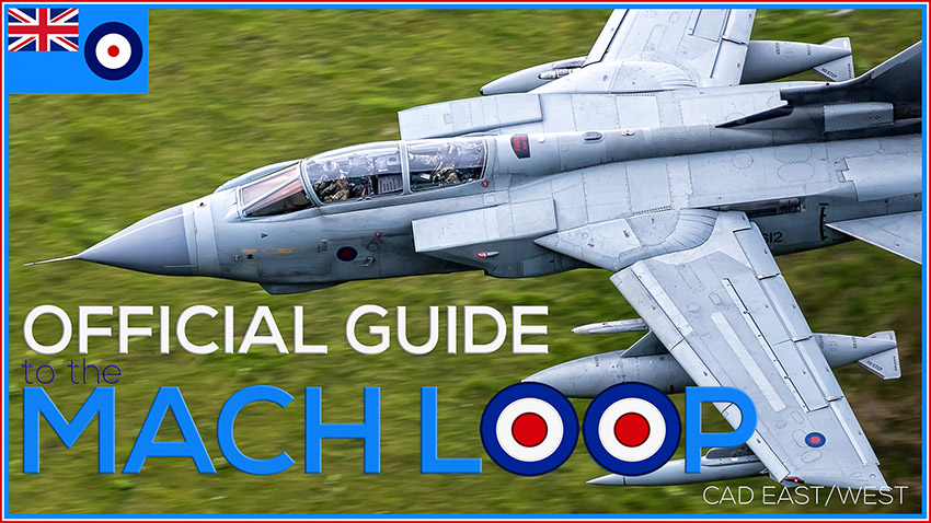
Mach Loop
Mach Loop – The Official Guide to Cad East and West
1st TIME? WATCH THIS FOR ALL THE INFO YOU NEED
Mach Loop – The Official Guide
As a follow up to my Mach Loop Guide (see video) I have created this web page to outline everything you need to know about travelling to the Mach Loop and how to take pictures whilst you’re there. I have outlined all the necessary address’s including Google Maps and various Postcodes for your Sat Nav. I’ve gone a little further than that too. I’ve covered where to stay and when.
I’d advise that you watch the video first and then plan your trip. It’s very important to point out right from the off, you’re never guaranteed to see aircraft. The military never advertises when they’re flying there, it’s a hit and miss affair I’m afraid!
Everyone at the Loop will tell you the same thing… it’s a magical place to sit and watch the world go by. If you manage to see any low flying aircraft whilst you’re there, it’s a bonus!
Hedging your bets… A few pointers that will definitely help.
- The Military only fly in the Loop when the visibility is fairly good or better.
- The Military only fly in the Loop from Monday to Friday.
- Military Aircraft don’t fly during Bank Holidays!
COMMUNITY PROJECT
If you feel you can add to or alter any of the information on this page then please let me know. I’ll gladly share the information and credit you.
If you feel you have any interesting videos or pictures you’d like to share then pop the links below and I will gladly share them too (I will always credit the creator)


Mach Loop – The Official Guide to Cad East and West
BRIEF: This video is a snapshot of a 2-day visit I made to the Mach Loop (Wales) on the 27th & 28th of Jun 2017. It’s fully intended to offer the viewer an insight into what they can expect if they’re planning a similar trip. Nothing is a guarantee though!
This short film is fully intended to capture the emotions and dramas of visiting the Loop.
Images shot using a CANON 1DX MKII and a 100mm – 400mm MKII Lens
Thanks for your video. We found it useful on our last trip to the Mach loop. We didn’t abuse the local’s privileges either. We closed gates, parked carefully and cleaned up after ourselves. Great high quality video! Regards, Suresh , Florida,USA.
ADVICE: This video explains how to find Cad West/East. Where to Park, but more importantly than that, how to take the pictures.
We cover it all…
WHERE IS IT?
WHERE TO PARK?
HOW FAR IS IT TO WALK?
WHAT EQUIPMENT?
WHAT CAMERA?
WHAT LENS?
CAN I CAMP THERE?
WHERE CAN I STAY?

Where is it?
The Mach Loop or Machynlleth Loop consists of a series of valleys in the United Kingdom in West-Central Wales
The Mach Loop (also known as the Machynlleth Loop or CAD West among plane spotters) consists of a series of valleys in the United Kingdom in west-central Wales, notable for their use as low-level training areas for fast jet aircraft. The system of valleys lies 8 miles east of Barmouth and is nestled between the towns of Dolgellau to the north and Machynlleth to the south, from the latter of which it takes its name. The training area is within the Low Flying Area (LFA) LFA7, which covers most of Wales.
Aircraft which use the training area include Royal Air Force Airbus, A400M, Tornado, Typhoon, Hawk jets and C-130J as well as U.S. Air Force F-15C Eagles, F-15E Strike Eagles, F-22 Raptors, and F-35A Lightning IIs, which are based at RAF Lakenheath in eastern England. – Snapshot from Wikipedia
Use Google Maps and search for “Cad East/West car park” (SEE BELOW) The result should take you to the car park on the A487 This is the car park for Cad West/East.
For Cad East (only) simply follow the instructions on the above video.
WHERE DO I PARK?
For Cad West/East park in the Lay-by on the A487 as per Google Maps and if you want to park at the back of Cad East then simply follow the instructions in the video.
>>>>>>>>>> WARNING <<<<<<<<<<
Parking at Cad East – This is really important… Before you venture up to the back of Cad East you must bear the following in mind…
There isn’t an official Car Park there, just a couple of pull-in areas that everybody uses. There are 2 small areas where people leave their cars. In one area (see video) there is space for around 5 carefully parked cars. There is a second area for around 3 to 4 carefully parked cars. People also edge their cars onto the verges, but this isn’t recommended and could upset the Farmer and other road users. The verges are un-even, usually soft and boggy and it’s very easy to get stuck. I can vouch for that!
Furthermore, these areas will fill up by 7AM – Don’t even attempt to travel up the back road after this time, or you’ll find yourself travelling back down.
Park sensibly and don’t let this happen to you. CLICK (Credit = Ron Jones)
HOW FAR IS TO WALK?
Cad West – It takes around 15 minutes to walk to the lower viewing area. This is a steady climb. Perfect for anyone that is averagely fit. You can then venture further up to the higher viewing areas which will offer different viewing angles if you like. The climb really does get a little more intense. This is a real huff and puff hill.
Personally, I would suggest going higher only if you’re a fairly fit person and if you have a long lens. The further up you travel the further away from the aircraft you get.
Cad East – From the rear car park, it’s a steady 10-minute climb. (See Parking above before you go) Climbing up from Cad West’s car park is a lot more strenuous and takes around 25 minutes.
(Community Project) Maybe somebody could advise us in the comments below?
WHAT EQUIPMENT?
Other – If you’re there for the day I’d suggest the following but they’re not essential…
- Warm dry clothes (Dress in layers)
- Good strong waterproof Footwear
- Comfy fold-able chair (Amazon Recommended) or Crazy Creek PowerLounger (Amazon Recommended)
- Pop-Up Tent. (Amazon recommended)
A pop-up tent can be a lifesaver. Not literally but they keep you and your equipment dry. They offer shelter from the Sun & Rain. - Water (Plenty to drink)
- Refreshments
- Sun Cream
- Mosquito Cream (They can be annoying in the summer if it’s a still day) (Amazon Recommended)
Radio – The serious Loopers have radio scanners. I don’t have one, so I can’t comment. Do not bother buying a radio unless you intend to visit several times. They’re more of a hindrance to the casual visitor. If you are interested look here CLICK
(Community Project) Advice anyone? – comment below?
WHAT CAMERA, WHAT LENS?
Any camera will do. Some people just go for the experience. Some people are happy to just video the aircraft on their smartphones. If you’re serious about taking pictures, then I’d suggest any Camera, but with a long lens. A lens between 300-500mm would be perfect.
My Gear
Canon 1DX MKII – CLICK
Canon 5D MK IV – CLICK
Canon EF 70-200 mm f/2.8 L IS II USM Lens – CLICK
Canon EF 100-400mm f/4.5-5.6L IS II USM – CLICK
Canon 24-105mm “L” Lens MK II – CLICK
CAN I CAMP THERE?
The land at Cad East and West are owned by local farmers. They have both asked me to point out that Camping on their land is “Strictly Prohibited“
WHERE CAN I STAY?
Camping – Cwmrhwyddfor Farm Camp Site.
This site is situated just 3 miles away from Cad East/West Car Park. It is rated 4.6 stars on Google. It has just enough amenities and is picturesque. The Farmer is called Hugh Notting. He’s a spot on guy and embraces photography and photographers.
His Rates are very reasonable too!
CONTACT: 01654 761286
Land Owner & Farmer: Hugh Notting
Address: Llanfihangel-y-pennant, Llanfihangel-y-Pennant, Tywyn LL36 9TS
I’m not on commission put please let him know you found his info from this page.
Self Catering Holiday Cottage – Stabal Holiday Cottage
The Self Catering Cottage Sleeps 4 and is situated right next to the Cad East Entry Gate. It has a Google 5 Star rating and is located right in the heart of The Loop. If you stayed here you could actually walk up the road to the Cad East viewing area. It’ll take just 25 minutes. You wouldn’t need to drive up at silly-o-clock in the morning to secure a parking spot either. For more info see their website here
Contact: 01341 422297
Land Owner & Farmer: Hugh Price
Address: Cefn Naw Clawdd, Cwm Hafod Oer, Dolgellau LL40 2SG
Website
I’m not on commission put please let him know you found his info from this page.
[envira-gallery id=”481″]
This video and accompanying web page covers it all!
COMMUNITY PROJECT:
I want to share mine and your experiences with others. Got any videos you want to share? Any Pictures? Any advice you feel will be appropriate?
SHARE YOUR VIDEOS
SHARE YOUR PICTURES
SHARE YOUR STORIES (good and bad)
Just add them into the description and I’ll share them on my web page. I will of course credit you back.
THANKS
Mach Loop the Official Guide
TAKE YOUR LITTER HOME
CONTRIBUTION:
Travel the Loop from the Cockpit of a Lockheed MC-130 MC-130 WOW!
CREDIT: stjohnpilot65
- Flight Timetable: CLICK
(Please bear in mind this timetable is for LFA7 which covers the whole of West Wales. Serious Loopers ignore this)
info (CREDIT = Kelvin Harrison & Randell John)
Government Guide to Low Flying in the UK. Where and when low flying happens. CLICK
Take this info with a pinch of salt! The Low Flying Area (LFA7) described, isn’t directly related to the Loop. It’s a general guide to flying throughout the whole of the Low Flying Area around Central-West Wales. Loopers generally ignore it.
Radio Frequencies: There is a very well written web page that seems to cover all of the frequencies that you’re ever likely to want and more. It’s probably just easier for you to go straight there. CLICK
- One thing I would add Gary is what to wear. Being nearly 1000ft up the side of a mountain the weather can change quickly. It can go from warm to freezing in a blink of an eye, it can rain, snow (dependent on the time of year) nevermind the wind factor! Wearing wind resistant quality outdoor clothing that you can take off if it gets warm is strongly advisable, you can always put them back on. You cover having a tent, I feel this is pretty essential too. I didn’t have one but wish I had, especially in that wind chill on the first day. Equally, camping gear of kettle, burner or flask with hot water is a recommendation too.
(Credit = John Chapman)
A Beginner’s Guide to the Mach Loop: By anonymous author see below
WEEKLY VLOGGING… Since I’ve committed to weekly vlogging, you get the best and the worst. Besides, it’s probably good to know that we don’t always have successful days!
I make at least one video a week, and I’ve got some amazing locations penned. Please make it worth my while and support the channel.
SMASH THAT LIKE BUTTON and SUBSCRIBE – I’ll love you forever!
YOUTUBE CHANNEL: CLICK
See more Vlogs: CLICK
Video Credits:
Presented By: Gary Gough
Music: The 126ers – Wish You’d Come True
Music: Jingle Punks – Cataclysmic Molten Core
PLEASE LIKE AND SUBSCRIBE YOUR
CONTRIBUTION:
The following is a fantastically written “Guide to the Mach Loop” that has never been published or shared online. The Author has granted me permission to share it, but wishes to remain anonymous which is a shame.
I haven’t changed it in any way so the author’s views may well vary from mine.
A Beginner’s Guide to the Mach Loop
For the beginners considering going to the loop for the first time. The focus will lie not so much on the spots or the camera gear but with all the other practical details for planning a trip to the loop, going there with the right expectations and mindset to be able to get as much out of it as possible.
The author is only an “intermediate” level looper with 4 visits (15 days) total experience. Any corrections/additions can be directed to gary@garygough.co.uk for inclusion in revised future versions of this guide.
Introduction
“The Mach Loop” is a series of valleys in Wales, the U.K. that serves as a military low-flying training area. The official designation is LFA7, Low Flying Area 7. Together the valleys form a circuit in which all kinds of military aircraft and helicopters from multiple nations regularly go to practice their low flying skills. Occasionally, especially at weekends, civilian traffic can also be spotted.
The traffic flow is always counterclockwise and in the north and west, there are several popular locations where people can climb the surrounding mountains to enjoy the show and take pictures in a way that mimics air-to-air photography.
The aircrews flying in the loop are very well aware of the presence of photographers and may or may not interact/assist your creation of some really nice shots.
Name
The Machynlleth Loop. Aviation heads easily confuse this with Ernest Mach and the speed of sound but the name actually derives from the village of Machynlleth just south of the southwest corner of the loop. Machynlleth like many Welsh names are naturally abbreviated and become “mach” with the expected pronunciation in daily speech.
Used By
R.A.F and USAF primarily but other NATO member states aircraft can be seen occasionally as well as aircraft visiting RIAT. Red Arrows or part thereof can sometimes be spotted passing through the loop.
Aircraft Types
Common: Hawk, Eagle, Tornado, Typhoon, C130, various helicopters such as Apache and Chinook.
Rarely/Occasionally/once: Alpha Jet, Jet Provost, F16, F22, F35.
Getting more common (2017) Osprey, A400M
When
Any day they are flying, the weather is acceptable and they have some time and fuel to spare. There is no such thing as a timetable for the loop and going there is a gamble in many respects. However, when the weather is fair you will most likely see something during a whole day stay. Traffic has been seen as early as around 7 and well into the darkness but most typically you want to be there from 8 in the morning to about 5-7 in the evening. Also, see the section on parking.
Please note that the air forces mostly operate office hours and the chance of seeing anything during a weekend or bank holiday is skinny to none.
Ongoing major exercises will, of course, affect all of the above, including no action at all if the forces are deployed elsewhere.
Factors Affecting Traffic
The most apparent one is of course the weather. Secondly, if they have time, fuel and desire to go for some low level that day. There are however some other things that can really kill your day.
Paragliding and helicopters with under-slung loads cause for temporary NOTAM’s that will effectively close parts of or even the whole loop area for hours or even days.
Factors Affecting Visitor Count
Some national holidays such as school breaks will bring more people to the loop. Also, summertime is a high as well as in the weeks around RIAT. Rumours of rare flying visitors will also affect the number of people on the hills and parking.
Where to Stay
See above recommendations
Getting to the Spots
Having a car is basically the only way unless you enjoy walking or biking. There is no bus service or charter coaches to take you there. This is very much the countryside and you need to take care of yourself. There are taxi services in the area but cell coverage is poor so when you are done and want to leave, this can prove tricky. You will most likely bump into other like-minded people and may be able to share a car.
Parking
Most of the spots have very limited parking possibilities. Space typically used are standard road laybys where you can fit anything from 2-30 cars depending on the spot. Please adhere to signage and do not waste space, park smart and more cars can fit in and people will appreciate you more.
Bwlch: If you are a party travelling in 2 cars, please park the car’s bumper to bumper and not side by side. People knowing each other or agreeing on conditions can also park this way. Better to block a friend in and leaving space for “singles” to park towards the fence.
Due to the parking constraints in many of the spots, you need to consider leaving your accommodation really early to ensure a spot. If you are a group, if possible please share vehicles. By early I mean on-site no later than 7.
What You Can Expect To See
Nothing. This is really the preferable mindset. The loop comes with no guarantees whatsoever. But apart from that, the lucky ones may see:
– USAF F-15’s.
– R.A.F Tornado, Typhoon, Hawk, C130 and more
Usually, R.A.F are bolder and they also have a slightly lower hard deck for low flying than what USAF do. A lot of the USAF pilots are also in training and have not been flying in the loop before, or even at low-level so their personal minimums will take them higher through the loop than most of the RAF jocks.
You will be able to take photos of the aircraft from above and level with their flight paths and thus getting pics with the aircraft “landlocked”, that is appearing as though you had been flying with them. With a good lens and some talent, you will also be able to get excellent cockpit shots, maybe even with the aircrew waiving at you.
The more time you can afford to stay in the loop (in terms of days) the higher the chance of getting to see some traffic (duh!).
Flying Rules in the Loop
- Left-hand circuit (counter-clockwise).
- Never inverted.
- No use of afterburners (reheaters).
- Max 2 complete circuits per aircraft and time.
Loop Manners
- Be considerate!
- Park effectively, allow as many others as possible to join.
- No littering, you are on private property and the day someone’s litter hurts a sheep, the looping days are over for everyone.
- Adhere to signage, particularly at Bwlch where you must never block the gates!
- Close farmers gates behind you or make sure the car after you does!
- Think twice before publishing photos that can get the airmen in trouble (burners, inverted, obscenities). Doing so can also give you a bad rep among veteran loopers. Most FB-groups will ban you if you do.
- Accept recommendations and reprimands from more experienced loopers, they know what they are talking about and their minds are set on what is good for the loop and your safety.
- Keep dogs on a lead unless you are VERY sure you can stop them from going after the sheep.
All violations of manner and common sense on these spots will jeopardize the future of the loop both from farmers blocking off access and from the air forces moving elsewhere if they start viewing the loop as a risk for them or the general public.
Absolute No-No!
– Use of drones or any other flying device or object that risk intentionally or unintentionally getting airborne and could pose a danger to incoming jets.
Who Can Go? What About My Kids? Pets?
The different spots have different characteristics and the difficulty level varies a lot. Still keep in mind that all spots require that you climb up to a level where you are above the aircraft you want to be watching. Even rather unfit people can do it as long as they take it slowly, not pushing on too hard.
For families with kids, Cad West is the spot you want to visit. The climb is done by traversing trails and at the steepest parts you follow a fence that you can hold on to if needed. Once up there, there are no sudden steep areas that you could accidentally fall down from. Sheep are omnipresent in the loop area and they are roaming the same hills you are so keep that in mind if you bring your dog. Farmers tend to be very upset by anything else but their own sheepdog hunting the sheep.
Wildlife / Animals / Dangers
Where there are sheep, there are ticks.
Snakes have been reported – mind your step.
Falling off a cliff…
All joking aside, people get hurt in the loop every year. Please appreciate the challenge you accept when going to the loop.
Weather and Gear
Weather shifts can be dramatic in the loop and it can be hard to dress for all circumstances, especially in the spring and fall. When the sun is shining you wish for shorts and a t-shirt, then clouds form and wind picks up, a rain shower starts and you would give your left arm for a tent with central heating in it or for a teleportation device to get you off the mountain in a hurry. Do not fool yourself by thinking that at least it will always be reasonably warm in the summer. It is not. Period. Bad weather
will bring unbelievable cold even in July.
But the basics:
ALWAYS use good footwear. Disregard any other advice I give you in here except this. Get some proper outdoor boots with good treading and preferably with some ankle support. The terrain is rock and grass, both get horribly slippery real quick, morning dew can increase the climbing difficulty by 30%.
In many places, the rocks are loose and you have to carefully plan your steps and if you lose balance, which you inevitably will at some point, the shoes may be the only thing between you and a fracture, or in a worst-case, the afterlife. Navigating this type of terrain is not a game so gearing up properly is very smart.
Dress in layers (onion principle), helps preserve heat during long periods of inactivity with wind and downpour and you can easily shed as many layers as required when the sun comes out again. Bring a spare layer since the climb usually soaks the layer closest to your body.
Always bring rain protection for yourself and your gear. Bear in mind that the ground gets wet too so you need to water-proof anything that will be sitting directly on the ground. Anything from a solid plastic bag to professional outdoor protection products will do the trick.
You will see that some people carry different quick-erect type tents. If you care to carry one they are fantastic when the weather goes sour on you and you will get lots of envious stares from the people sitting outside curled up under their ponchos and umbrellas. They are rather inexpensive, you can get them from approx. £25 and up.
Oh, umbrellas. If you have a small light one, pack it along but mostly when the rain comes, so does the wind and it can quickly get beyond the point where an umbrella will turn inside out.
Some people find good use for walking sticks when climbing for extra grip and stability.
Sitting gear, I mentioned protection for things you put on wet ground. But, if you are going to spend maybe 10h on the mountain, it may be wise to bring something to sit down on, wet or not. Folding camping chairs are common among loopers although it can be a challenge to find a flat enough surface to put them on. Securing it when the wind picks up can also be an issue.
Inflatable pillows are nice but not very aerodynamic so attach them to something that will keep it from getting airborne. This goes for any loose items that can get airborne, a tent pin and a string/lanyard will save the day and your gear.
Sun Protection
A must for fair days, you will find yourself sitting outdoors for 10h straight with no shadow. Also, bring sunglasses, they will be comfy and also help when looking for incoming traffic.
Head Protection
Some kind of hat or cap is good. Keeps you from sunburn on the scalp and provides extra shade for the eyes and neck. Bring one which fits snugly or has a chin strap to secure it, yes, it’s that wind again!
Food and Drinks
Nothing of the sort is readily available in the immediate loop area. Stock up on water (plenty!), sandwiches, sweets and whatnot at the nearest SPAR or gas station in Dolgellau or any other village of your convenience. The nearest lodging and restaurant is the Cross Foxes which is situated under the area called “the roundabout” between The Exit and Cad (see spots section).
Lingo
Carparked is what you get when you’re still in the parking lot or have left too early and get
overflown by that plane you’ve been waiting for all day.
- Incoming! – It’s kind of self-explanatory but that is what you collectively yell/repeat when someone has spotted incoming traffic to alert everyone else. Or any other exclamative word, such as OY! Or the type or direction from which it’s approaching.
- Tiffy – Nickname for Eurofighter Typhoon II
- Tonka – Nickname for Panavia Tornado.
- Landlocked – Picture of aircraft with only terrain as the backdrop.
- Togger – Photographer
- Office Shot – Photo straight in/down into the cockpit.
Time For a Full Circuit
If you think the traffic will go full circuit or for a second lap, lap time is about 3-5min depending on the aircraft type. Don’t let your guard down though, he may have buddies joining the party during that time.
Intelligence
Cell phone and air-band radio in own sections below.
Providing you can get Internet service where you are, there are a couple of Facebook groups that will have daily intel posts where observations from people in the area, people using unfiltered ADS-B online services or people listening on air-band receivers at home or on the hills are posted as comments. There are also a number of dedicated “heads-up”-groups.
These groups and to some extent forums such as Fox2 or FighterContol can also provide insights into coming or ongoing exercises and unique visitors that may come to the loop.
Get acquainted with the regulars, they are usually very friendly and are regular walking information parlours and they exchange information that not always reaches wider circles. A few of them are more or less connected with air force insiders.
Cell Phone
Do not expect coverage. No matter what subscription/provider you are on, coverage is poor in most spots. If any carrier is a little better than the others, at least in parts of the loop area, it’s EE.
Airband Radio
For the casual visitor going there once and maybe never more, the use of a radio will give more headache than help. You need a good radio with a good aerial (not the included one), there is a bunch of frequencies to monitor (can be found online or ask someone on-site). The terminology used takes a lot of experience to get into and there is no one frequency and no particular clearance for them to enter the loop.
The key phrase you want to listen for is “low level”, combine that with where they are/who they are talking to and you can derive that at least there is an increased chance something will show up soon. There will most likely be a number of people with experience and good equipment around you to help you out and/or who will pass the information they hear on to you.
Update: Lately (2017) the NATO Low-level frequency (278Mhz, AM) has become more reliable and many flights now check in on it. When you hear something on it, get ready, you will likely have company within minutes or less.
“Radars” (ADS-B)
Only a small part of the military traffic actually use ADS-B. Mostly you will see transports and trainers, but occasionally also front-liners taking off, or crossing civilian airspace.
- Flightradar24 is more or less useless in the loop as they filter out most military traffic.
- adsbexchange.com set to show only traffic deemed as military is quite good.
- 360radar.co.uk is a subscription service used by many loopers.
Head Warning / Spotting Incoming Aircraft
This will vary with the spot you visit. Generally, the head warning times are between short and very short, say 5-20s. You cannot rely on hearing the aircraft, the wind can cancel out the noise and significantly reduce the head warning you get. Some of the spots also have terrain blocking the view so that incoming can only be seen for a few seconds before passing you. Bwlch and Cad West have the best head warning times of around 10-20s depending on visibility and detection.
Being on top of your game and concentrated on looking where you know the aircraft will appear for hours on end is not possible for most people. Fortunately, there is strength in numbers and within the group. There will usually be one or more watching all the time. Think of it as a meerkat (suricate) clan on the lookout.
Some Words on Camera Equipment
Aviation photography is an equipment sport, there are few shortcuts if you want really good pictures. However, the loop will let you get away with decent pictures even with a mid-range camera and lens. The spots all have slightly different demands concerning focal lengths but if you have a zoom or telephoto lens reaching 200mm or more, you are well off in most of the spots. Friends attempting to use 500mm lenses quickly changed over to their 100-400mm lenses instead as they were getting too close and tracking/panning became virtually impossible.
Do mind that some of the spots are only good for part of the day as they become at least partly backlit late on. Cad East, Spur, Corris to name some.
Check Here to view the sun’s angles
Do not climb with your camera at the ready unless you have climbed that spot before and/or have a deep wallet. Falling on or dropping your camera here WILL break it. Also, use a camera bag or backpack for protection.
Unless you will have a truly epic day you do not need a very large memory card even if you are shooting raw, however speed and buffer size are of greater importance. I’ve had a superb week with plenty of traffic but with a window of only a few seconds for each, the total number of clicks remain much lower than at an airshow or airport. Returning from a really good week I had bagged only about 1 000 exposures and not all of them were of aircraft.
The Spots
So, now the golden nugget(s). I will only cover them briefly for reference in this doc.
Bwlch (pronounced “bulk”)
The direction of flow: Right to Left
Hillside faces: North-East (Aircraft pass from East to West)
Type of shot: Topside or level pass. Head-on and turning when approaching through the valley from the east.
Climb: 30-50min depending on fitness and conditions. 2nd hardest climb in the loop of the common ones.
Parking space: Limited, approx. 10-12 cars max if everybody uses their head and not their ego when parking.
Lighting: Good all day.
Cad West
The direction of flow: Left to Right
Hillside faces: South-east
Type of shot: Dramatic topside or level pass. Behind and turning left to Corris over lake Tal-y-Ilyn.
Famous “fence shots”.
Climb: 20-30 depending on fitness and conditions. Easy climb. Trails traversing the hillside horizontally.
Parking space: Quite generous, largest layby in the loop. Approx 30 cars.
Lighting: Good all day.
Cad East
The direction of flow: Right to Left
Hillside faces: North-West (Aircraft pass from East to West)
Type of shot: Belly shots, head-on, level pass
Climb: Offers the possibility to drive up close to the peak, 10min easy climb from parking.
Parking space: Good if parked at Cad West layby. Very limited if driving up, maybe 3-7 cars if you get creative.
Lighting: Only really good in the morning but ok most of the day.
Corris Corner
The direction of flow: Right to Left
Hillside faces: North to South West
Type of shot: Side, topside, lake background.
Climb: 20-30min medium-difficult.
Parking space: Layby, maybe 5-10 cars max.
Lighting: Only really good before noon.
Bluebell
The direction of flow: Right to Left
Hillside faces: North (Aircraft pass from East to West)
Type of shot: Side on or dipped wings
Climb: 30min, most difficult in the loop, do not climb straight up.
Parking space: Layby, 3 cars max. Other possibilities further down towards Dinas.
Lighting: This can be tricky at times.
The Spur
The direction of flow: Left to Right
Hillside faces: South (Aircraft pass from East to West)
Type of shot:
Climb: 20 min.
Parking space: Layby, 2 cars max. Optionally stop a Bwlch layby.
Lighting:
The Exit
Same as Bwlch but turn right and head over toward the roundabout / Cross Foxes.
► WORKSHOPS
► MORE ABOUT ME
► WEBSITE
► FACEBOOK
► YOUTUBE
► INSTAGRAM
My Landscape Photography Gear:
Vlogging Gear
(Please note these are Amazon Affiliate links. I only receive pennies but it all helps!)
(My main Vlogging camera) Canon M50 – CLICK
Canon M50 (Vlogging kit) – CLICK
Camera Canon PowerShot G7 X Mark II – CLICK
Camera Canon PowerShot G7 X Mark III – CLICK
(I still use the MKII version)
Joby GorillaPod Original Tripod – CLICK
Joby Gorillapod Ball Head for SLR Camera – CLICK
Camera Gear
Canon 1DX MKII – CLICK
Canon 5D MK IV – CLICK
Canon EF 70-200 mm f/2.8 L IS II USM Lens – CLICK
Canon EF 100-400mm f/4.5-5.6L IS II USM – CLICK
Canon 24-105mm “L” Lens MK II – CLICK
Filters
Lee Filters LEE100 Long Exposure Kit – CLICK
Lee Filters Big Stopper (10 stop) ND Filter – CLICK
Lee Filters Soft ND Graduated Filter 0.9 – CLICK
Lee Filters Soft ND Graduated Neutral-Density Filter Kit – CLICK
Canon Camera Remote Control Cable TC-80N3 – CLICK
WEEKLY VLOGGING… Since I’ve committed to weekly vlogging, you get the best and the worst. Besides, it’s probably good to know that we don’t always have successful days!
I make at least one video a week, and I’ve got some amazing locations penned. Please make it worth my while and support the channel.
Comments are always welcome btw
Thank you
Gary
18/07/2017 Author Kevin Hancock
Hi Gary
Good informative video only been 3 times so far due to work but never mind, lots of good information there first time i went i was blowing a gale and had no shelter but did have warm clothes on, so yes tent and flask with soup or coffee is needed.
Hope you will be going around the rest of the loop plus finding any hidden spots to get a different view, or maybe some info for the less active like views from ground level and the sort of shots to expect.
Thanks
Kevin
18/07/2017 Author Gary Gough
Hi Kevin, Glad you liked the video. I fully intend to film at every view point, sooner or later 🙂
20/07/2017 Author Stephen Marnick
Gary, well done on producing such a really good video channel. You come across as very amiable and well-informed guy. I’ve only been to the Mach Loop three times but always managed to get decent photos. Will be going again soon.
Keep up the great work
Stephen
20/07/2017 Author Gary Gough
Cheers Stephen, Very kind of you to say. See you up there.
23/07/2017 Author Brian
Gary
Thank you very much for this valuable guide and your video, i’ll be coming from Canada next year and the Loop has been a long time want for me to check out
I have watched many videos and seen the pictures but, you have put it all together and with the info that i have always wondered about but never found answers to, as to parking, difficulty of the climb, etc
As mentioned above, you come across as a very amiable and well-informed guy, just the kind of guy i would like to run into when i get there
Thanks again and take care
Brian
29/07/2017 Author Gary Gough
Hi Brian, very kind of you to say. Let me know the dates you intend to visit and maybe we can meet up. PM me to gary@garygough.co.uk
19/09/2017 Author rick dugas
absolutely loved the video. while i will probably never get to visit the loop as it is a far piece from as my mate Mike says “the colonies” here in the US, yea get a lot of grief, i watch every one i find posted and those mike sends. as a veteran of the USAF the birds are in my blood. made it to England to RAF Mildenhall while tdy from Torrejon AB in Spain in the seventies although would not have had time to visit the loop if it was there at that time. nice to see what it takes to get these shots and are greatly appreciated. from Louisiana in the “colonies”, yea mike is laughing, thanks.
22/09/2017 Author Gary Gough
Hi Rick, colonies 🙂
Thanks for your the kind words. Appreciate that you’ve taken the time out to watch my video and found time to write such a nice email. Really appreciate it. Plenty more videos to come
14/11/2017 Author Martin Stockton
Many thanks for the tips regarding camera settings yesterday on Cad West. Spotting 3 F15’s one after the other was a welcome relief just as I was contemplating going back down to the motor. Watching the toggers further up the hill and noting when they raised their cameras was a big help. Pictures taken were below the standard I wanted but the experience was invaluable and I will be back.
16/11/2017 Author Gary Gough
Hi Martin, oh that’s great. Really glad it helped. It just seemed to happen in a flash, when we all thought the day was going to draw a blank.
The video including the pictures I took won’t be processed for a couple of weeks. I’ll drop you a line when it goes live.
Did you get any good shots? I’d be very interested in showing them in my video if you’d allow me too? It would be great for others to see shots taken from your perspective. You can email them to gary@garygough.co.uk. I will, of course, give you full credit.
Speak soon
Gary
21/01/2018 Author Chris A Jones
where would someone from the U.S. fly into to tour the Mach Loop?
ty for your time and any info you can pass on .
28/01/2018 Author Gary Gough
Hi Chris. Manchester or London is probably the best. Either way, you’ll still have a 2 to 4-hour drive to reach the Loop. Hope this helps
23/02/2018 Author Colin Marrow
My friend and I are Just back from our first ever trip to the Loop. We used your video as our guide and spent three days on Cad East. We were very lucky with the weather and aircraft and saw a lot of Hawks, several F-15s, a few Typhoons plus a Hercules and an A400. Thanks to your tips and advice we had a great time, thank you.
25/02/2018 Author Gary Gough
Hi Colin, So glad you found the video helped. Better still, you managed to see loads of aircraft and hopefully bagged yourself a few great shots. More importantly, I’m grateful that you’ve returned to this page and shared your experience. Thank you
02/04/2018 Author Chris Raezer
Gary,
Really, really great video and information. My wife and I are traveling from Seattle to the UK in mid-October and the Mach Loop has always been on my bucket list. Your video convinced me to just go ahead and make time to do it. The part in the video where you show the gate to Cad East also gave me the idea to look for a holiday cottage in the area. I found one right under the flight path close by that was available when we will be there. That’s now booked and paid for, but I think I accidentally forgot to tell my wife there might be some occasional noise in the neighborhood (please dear God, let there be noise in the neighborhood). I started watching your other videos and subscribed to your channel. Good stuff.
I shoot for an airliner manufacturer in Seattle so I suppose this is a bit of a busman’s holiday (a few examples of what I do: https://goo.gl/bPnJqs, https://goo.gl/45BQ5m , https://adobe.ly/2Grrkp4, https://goo.gl/tHPsF1). Your advice in the video confirmed my hunch on what to bring. To travel light I’m just bringing my 1D X Mark II, 16-35, 24-105 and 100-400 (plus tripod and usual essentials). Do you find 400mm on a full frame body gives you enough reach? I’ll have my 1.4 extender but I’m debating whether to also bring my 7D Mark II if I need more focal length. My percentage of keepers is usually a bit higher with the cropped sensor and no extender than using the extender on my 1D. What do you think?
I’m sure I’ll have more questions as I get closer to October. Hope I see you on the hill and drop me a line if you find yourself in Seattle.
Cheers,
Chris
03/04/2018 Author Gary Gough
Hi Chris, Glad you found the video helpful. Happy to meet you on the hill for a day or 2, I’ll check my diary. Fingers crossed for lots of noise 🙂
The 100-400 will be more than adequate. Higher than a 400mm and you’ll just find it harder to pan with the jets at speed as you are aware. Not sure why you’d prefer the 7D over the 1DX? The 7D is just cropped tighter!
03/04/2018 Author Chris Raezer
Gary,
I hope your calendar works out in October!
I can see I wasn’t very clear about bringing my 7D. I definitely prefer my 1D X Mark II, but if I have a choice of adding an extender to the 1D or using the cropped frame 7D without an extender, I usually get better results with the 7D. The extender is the Mark II version, not the newer Mark III. I suspect I would be much happier with the results from that. But thankfully it sounds like it’s not an issue to worry about and I can save a bit of weight and space for something else in my bag.
Cheers,
Chris
18/07/2018 Author Jon Radband
Hi Gary
Just a note. I am lucky enough to live in upper corris. I am up on the hills most days walking my Belgium malinois. If you ever need a place to stay for a couple of nights let me know as I have 2 spare rooms and the wife makes a fab breakfast 🤩 there are a few spots that us locals like to keep to ourselves for spotting the planes and I’m happy to take you some time. I just started in photography and looking forward to taking some real photos of this wonderful flying machines.
31/07/2018 Author Gary Gough
Hi Jon, Thank you for your very kind gesture. I will gladly take you up on your offer. Thank you
16/02/2019 Author Dan Stefan
Hi,
Can you please give me some details about your rooms? A link maybe? Thank you.
Me and my friends (we are 4 in total) plan to come to Mach Loop from 12 to 17 of may. We choose the month of may because we saw from the last years that the best chances for a good weather are in that month. It will be a nice road trip for about 3000 km :)) We visit other airports on the way, but we will stay 5 nights in the proximity of Mach Loop.
Thank You.
PS: Gary, thank you for the tips, nicely done.
17/02/2019 Author Gary Gough
There are plenty of places to stay close to the Mach Loop. Just Google B&B’s, Hotels or Camp Sites. The closest town is Dolgellau. They have decent accommodation. I usually stay in a Bunkhouse which is very cheap. Take a look here… Torrent Walk Campsite
Hope this helps
Gary
10/01/2019 Author Geoff Adams
Gary,
You may already know this but the RAF do advertise when they are flying the Mach Loop. The URL link is below.
https://www.gov.uk/government/publications/operational-low-flying-training-timetable
31/01/2019 Author Gary Gough
Hi Geoff, This timetable is for the LFA7 route which pretty much covers most of North Wales. Therefore it doesn’t relate to the Mach Loop. I wouldn’t pay any attention to it, Loopers ignore it.
14/02/2019 Author Steve Yates
Hi Gary, the link for the scanner frequencies website, does my head in, it’s a constant redirect to “you have won a prize” sites. Steve
17/02/2019 Author Gary Gough
I hate that, really annoying. I’d suggest joining a Mach Loop FB Group and ask them. Try this group… MACH LOOP OPEN FORUM
Hope this helps
Gary
30/03/2019 Author Richard Marks
Hi Gary. I found you video’s on the Cads massively helpful for my first visit last year. I am visiting again in April and just wanted to know if you had any videos on Bwlch? I have seen Google images on where to park but unsure where exactly to go!
Thanks, Rich
31/03/2019 Author Gary Gough
I haven’t made on yet. Park here and walk up the hill. It’s really easy to find. It’s just 10 minutes away from Cad West and East. https://tinyurl.com/y37uwej8
Hope this helps. Please be aware the RAF aren’t flying through the Loop at the moment. Their ban is being reviewed in May/Jun. Let me know how you get on, please.
Regards
Gary
16/04/2021 Author Kevin Lamberth
Hi Gary
Cracking video, very informative. Not sure about the easy 10 minute walk up the back of Cad East though. LOL. I must be getting old. I’m an ex Army veteran and with a former Royal Marine we set up shop on the top of Cad East and had bacon sandwiches and a brew, working on the theory that anybody can rough it. Got some funny looks. LOL
I noticed you put shutter speeds etc on your photos, may I suggest to your readers that if taking photos of helicopters the shutter speed needs to be reduced to avoid the rotor’s “freezing”
Excellent video, brilliant for the first timer. Keep up the good work.
17/04/2021 Author Gary
I need to be there when you’re there with your shop 🙂
Shutter speeds when shooting heli’s are as you said, the slower the better. As we all know the bin rate will be quite high though, but that’s what it’s all about 👍👍
Cheers, see you up there xx
Gary
15/03/2022 Author Steve Wearne
Hi Gary, I’m from Cornwall and in the Snowdonia area walking / hiking this week. I have been wanting to go up to CAD West for many years and today finally got around to it. Your hints and tips worked a treat and I just wanted to thank you for that. Not a hugely busy day but 48FW sent 4 F-15Es through and the photos I managed to achieve made me a happy man tonight. Good work with the videos… although the Mach Loop ones are at least a couple years old they were still very helpful.
Shutter priority, 1/1250, AutoISO… Great results👍👌
04/04/2022 Author Gary
Excellent news Steve. Glad you had a great time 👍👍
03/10/2022 Author Antony Michael Finbow
Hi Gary. Greatly admire your pics of the Mach Loop. I’ve found a rough area on google maps but can’t find the road between Cad West and Cad East. Now I’ve got a bit more time on my hands, due to retirement, I’d like to while away a few hours on the hillside. As well as that, it looks like a nice run for me and my Mazda MX5.
Thank you in advance.
Keep up the great videos.
14/10/2022 Author Gary
All the info and more are here: https://www.shootsmart.co.uk/mach-loop/
Watch this video to discover the road up the back of Cad East https://youtu.be/UNmNVEJQsVU
See you up there!